Exploring the Muddy Fork Cispus River, Washington
Bridge to FR 21
November, 2012
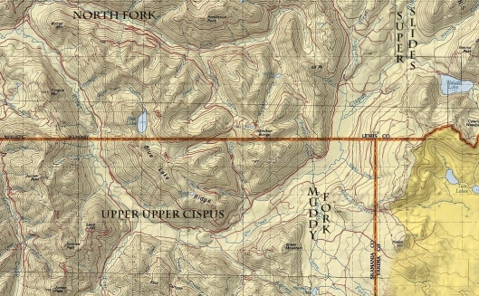
Forest Road 23 that runs from Randle to Trout Lake is a short cut to say the least at accessing the Cispus and Cowlitz drainage’s. In the winter it is snowed over and access is blocked off until spring. The amount of snowfall during the winter will determine when the road reopens in the spring or summer… The reason this little shortcut is so important is due to the fact that your other option is to drive four hours around to Portland, up I5 and back over to Randle. FR 23 takes an hour to get to the Cispus from Trout Lake.
A van loaded with kayaks, a topographical map, all the gear needed, and enough determination to hike through the pouring rain or snow to visit a new secluded area; for us this leads to documenting the runs that no one else wants to. How do you think classics whitewater runs are born? Proof; exploring, documenting and putting in the logistical work, hours looking over maps then driving the closest roads to where you want to go just to see if they are still roads or have turned into miles of trails at this point, going in and having to hike out or run out of daylight, then coming back and passing on the word to those interested based on what you had found. What happens between logistical work and passing on the good news can create some unforgettable experiences and hair pulling frustration.
Once you get to a point where you have paddled everything that looks fun in the local guidebook it’s only natural to look for something new. The Cascade Mountain Range isn’t a bad place to look, close your eyes and point to your next adventure. Brett had his eye on a curiously steep tributary of the Cispus River, intriguingly named, the Muddy Fork. It looked like a big enough drainage, steep enough, but not too steep, and easy access, why not check it out? We hadn’t heard any information on it as far as scouting or paddling attempts. That mixed with other un-seen creeks in the area lead us to the take-out bridge on the Muddy Fork. Keel Bightman and I drove north over FR23 to meet Brett Barton just before the snow level dropped.
At the take-out it looked good, definitely large enough to paddle and the flow looked low, but manageable. We decided to hike up from the take-out and take a look at the character of the creek to get an idea of what we were getting into. The first couple rapids had a rocky and trashy character in the creek bed. The section that we wanted to look at was only 2.5 miles long and the forest was easy to walk through so Keel and I decided to gear up and hike it without a boat. Brett was fired up to paddle and decided to take his boat, just in case.
We drove up the road in high spirits since we were all “off the couch” as they say, meaning we hadn’t paddled or been in search of whitewater in quite sometime. The mapped showed a steady loss in gradient for about a mile and a tighter pinch and steeper gradient in the middle of the run. It looked like a section that could possibly be called a worthy section of whitewater, but we had to see exactly what was in the canyon between the bridges. Our road was leading us into the snow line…”why did we just pass the Pacific Crest Trail?” came from the back of the van. “Huh, we shouldn’t have passed that.” I thought. But we hadn’t driven over a bridge… We quickly turned around in the accumulating snow and headed back down the hill. Watching the map much closer at this point, we pinpointed our put-in from landmarks on the map as we approached it and discovered that the creek was small enough that it passed through a culvert under the road and if you were not looking off to the side when you drove by, you would miss it.

At the put-in bridge it looked like less water, similar trashy (very jagged dark basalt) rock, and easy gradient. Brett put his boat in the water and Keel and I made our way downstream along the right bank. It didn’t take long to come to a log that blocked the entire creek, this is what we always dread seeing, a log portage in the first quarter mile. Next came a couple passable rapids with logs hear and there. The creek was trying to clean up in character and it pinched down into a channel just wide enough for a boat to go through. I looked at it closely and went up to give Brett the information that I had seen. “…you’ll need some right angle and paddle on the left to make it through the slot and there is an overhanging rock on the right side, you might want to duck your head left at the same time…” It gets complicated when someone explains something this precise and you have to execute those instructions to make your line go smooth, this is why paddling with people that you have mutual respect for and trust with their word, it could mean the difference between having fun or getting hurt. Brett headed into the pinch and executed the line perfectly. He looked a little like a pinball bouncing through the pinch and out, but that was the line; whatever it takes to make it down the creek safe and efficient. Exploratory paddling, especially in the winter, always makes you look at your time frame. Any hike in takes away from your daylight, major portages around waterfalls or mini-gorges takes even more, constant portages due to logs across the creek eats away more time and starts to exhaust you, the more people you have on the trip takes even more time at every step. All of these factors force explorers to be as efficient as possible and much of the exploring is done in the fall and winter months when the rain comes and just before the snow level drops, which locks in the higher elevations until summer.

We started running into rapids that pinched too tight for even a boat to fit through, then more wood in a couple fun looking boulder gardens. This seemed to be the standard character to this Muddy Fork.

Ahead of us the creek dropped down an obvious horizon line with a log propped on the lip and dropping downstream out of sight. Just beyond the horizon the tree line angled downhill and dropped around a left bend. We had arrived at our steep section.

At close inspection, and to no surprise at this point, the creek tilted on end and spilled through a series of broken falls and a gauntlet of shattered logs as far as the eye could see. A ribbon of white weaved down though the forest and around the corner. Judging by the landscape our easiest escape was up the right on top of the ridgeline and down to wherever the creek eased up again. We hiked up and into the woods; it was easy going with very little undergrowth. The creek had cut down into the forest and we could see a bend to the right below where the creek looked like it was easing up and there could be a suitable place to get back in the water. Once we made it to that spot, the creek was still littered with wood so we continued downstream.
Soon we were on familiar ground and came across the rapids we had scouted before our trip. Much to our surprise these rapids looked much more fun than what we had just seen. The take out was within sight and we hiked down to put on dry clothes. The creek hadn’t been exactly what we were looking for. We had hoped for cleaner bedrock and rapids that were fun yet challenging with more time (if not all) spent in the boat, instead the rapids that were there were full of jagged rocks and blocked by logs in many rapids. Many could read this and say that we wasted hours or even a whole day just to get shut down, but we saw it as another adventure; looking on a map, finding a new location, and going to explore with close friends, high in the hills, deep in a small valley, and far from civilization. We didn’t find what we hoped to find, but it was far from a wasted day.
 I love Washington’s forests!


